
 Click on image for list of participants |
Erongo, Upper Brandberg and Mikberg 29th May - 15thJune, 2023 Site references based on numbering system of Harald Pager (Upper Brandberg) and Ernst-Rudolf Scherz False colour images processed with dStretch, a freely available software developed by Jon Harman |
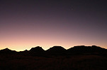
Day 0. - Windhoek
Day 1. - Windhoek - Ameib
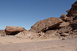
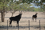
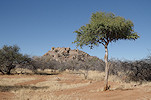
Starting out early in the morning, we comfortably reached Ameib before midday, and after settling in we immediately set out to continue exploring where with Uwe we left off the previous year. Setting out on foot from the Bull Party car park, we headed towards the rocky hill about a kilometre to the east, passing the Klein Ameib spring with a large herd of giraffe in residence.


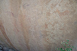
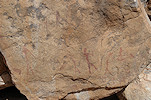
A year earlier we searched here for Scherz's site 147/C, but failed to find it. However, we did find some meager paintings on a large round boulder, which clearly was not the panel we were looking for. Now, re-examining the same boulder (147/D) we found another panel hidden by a shrub that we completely missed the year before.


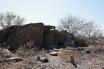
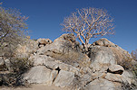
This time with a better understanding of the terrain and the likely spots it did not take long to find Scherz's site, a nice panel of human figures on the side of a huge boulder.


Having finished much earlier than anticipated, we still had a few hours of sunlight left. With Uwe we planned to visit the foot of the mountain to the north west of the house, where Scherz reported another two sites. However Pieter, out local guide knew of another (apparently unpublished) painting to the north east of the house, so we set out to see that one first. Reaching it, we were surprised to find a panel of Australian Wandjina style figures, obviously modern. There must be quite a backstory, possibly they have been created by the same French artist who made the panel of reproductions near Bulls Party.


We continued along the granite plates at the foot of the mountain, checking every larger boulder almost all the way to Paradise Spring, but found nothing. Obviously we were searching in the wrong place again, re-reading the description of Scherz the sites are likely to be on boulders some distance from the foot of the mountain, a task left for next year.


Day 2. - Ameib
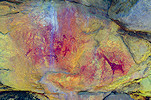
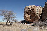
In the morning after breakfast with Pieter we set out to the "Tal der Riesenblöcke" (valley of the giant boulder), starting at the main site (152/F) which was fully exposed to the afternoon sun the previous year, so we could only photograph it in small patches. Now all of the rock was in the shade, revealing the true extent of the paintings. We could do a leisurely photo session, only finishing when the strip of shadow at the base of the main panel started to disappear.


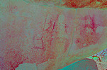
Scherz recorded two more sites further up the valley, for which we had no time left the year before. Now we had the whole day, so we continued following Scherz's map and description. First we found nothing at the likely spot, but continuing we did come up on site 152/L at a distance of more than double from the giant boulder than what Scherz wrote. On the spot we only saw a few red smudges on the sunlit rock face, but dStretch reveals a number of well preserved tiny figures.


Site 152/M was somewhere further upstream. By now we knew that in this area the map of Scherz was quite useless, so we spread out and checked all the boulders along the edge of the valley, finally we found the small boulder with a shallow shelter underneath nearly a kilometre above the giant boulder.


There were a number of suitable looking huge boulders along the western side of the valley, where Scherz reported no sites. With plenty of time on our hands it was worth taking a look on the way back, but apparently Scherz did a thorough job, we only found a single smudged trace of paint on a rock (152/R), everything else was empty.


We continued to the old mine dam to show Magdi the splendid panel with the rhino-headed therianthropes (154/D). We spent a long time looking for site 154/K which is described to be in a cave somewhere upstream along the east bank of the river, but we found nothing despite searching several likely spots. Possibly here too the distance was underestimated by Scherz and we should have looked much further upstream.


Returning towards the house we stopped at the likely spot of site 152/N, described as a large boulder with numerous paintings. The boulder was rather obvious, and we did find the very faint paintings on the far side. I only realised after returning home and checking with dStretch that we did not find the main site but an adjacent lesser one, the principal panels must have been on an adjacent and less conspicuous boulder.


By now it was mid-afternoon, we finished the day at the cluster of sites near Paradise Spring. These we visited in June 2017, but it was immediately after the camera accident, this was the spot where the battered body finally gave up its last breath. Now I had the opportunity to take photos, some of these sites are quite impressive. It also became clear that the large faint panel with a number of rhinoceros was not recorded by Scherz, it does not match any of the four sites he describes here.


We had a long full day, we got back to the house an hour before sunset, leaving some time to relax and lick the wounds (literally, plenty of them with the thorns everywhere) before sundowner and dinner.

Day 3. - Ameib - Uis - Karoab Gorge
After breakfast we departed from Ameib, taking the direct route to Uis passing near Spitzkoppe. We drove pretty much without interruption, save for a brief stop at the abandoned mining town of Nainais about half-way, adjacent to the Omaruru river.


In Uis we only stopped to leave some of our gear with Analene, then we continued to the ticket office at the Tsisab gorge where John, our NHC guide was waiting for us. After some quick greetings we rolled again, taking the track across the Ugab river then passing to the north of the Brandberg. It was very dry everywhere, it was obvious we could not expect to find any water on the mountain, we'll have to make do with what we can carry.


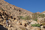
We reached the confluence of the Ugab and Karoab by early afternoon. Unlike the lower part of other valleys of the Brandberg, here it is only possible to drive in for a short distance, as the gorge soon narrows to a ravine cutting through the schists that make up the terrain to the North and West of the Brandberg. We found a nice shady tree not far from the end of the motorable trail, where we could park the car leaving it out of the sun for most of the day. After a quick lunch to reduce the load to be carried, we set out on foot along the bed of the Karoab towards the proper foot of the Brandberg, still a good two kilometres away.


After a few hundred metres along the narrow gorge the country opened up again, with a broad flat valley leading right up to the foot of the Brandberg. There was no obvious trail, but the going was easy on the firm gravel.


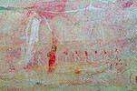
In little over an hour we reached the base of the mountain, and in another half an hour we reached the location of the first cluster of sites still in the gently rising lower section of the Karoab. We left our packs at a suitable sandy bivouac in the riverbed then set out to search for the two nearby sites. The first one, K53 was just below our campsite, a fine row of excellently preserved women in a very small shelter.


Site K52 was across the river surrounding a small terrace marked by a prominent Brandberg acacia (Senegalia montis-usti). There are multiple panels of rather weathered paintings on several boulders facing the terrace.


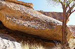
The big surprise is at the rear of one of the boulders, in an uncomfortable small low niche that barely counts as a shelter, and there is not even enough room for one person to enter properly. On the ceiling of the niche, in a very awkward, hard to photograph location there is a perfectly preserved panel of human figures, arguably one of the nicest panels on the Brandberg.


By the time we finished taking the photographs the sun had set, fortunately the moon just rose above the ridge to the east to provide some light as we made our way back to our bivouac. Due to the gentle slope we did not really feel it, but we gained almost 200 metres in altitude from the car to here, with our camp exactly on the 600m contour.


Day 4. - Karoab Gorge
We were up at first light to make the most of the shade and the cool of the morning now that we were starting the climb in earnest. After a quick coffee and leaving a bottle of reserve water for the way back, we turned towards the still gentle slope to make it to the second cluster of sites about six hundred metres further upstream, and about 100 metres higher.


The two sites K50 and K51 are next to each other, just beyond the 30m distance used by Pager to denote different sites. K51 is the lower one, just a few figures on the side of a huge boulder. K50 is a much larger site, with a spacious shelter under an enormous rock. Strangely there is just a small patch of paintings on the ceiling, all other panels are on small rocks lying at the rear floor of the shelter.


This is where the steep part of our route really commenced. We had about a kilometre of horizontal distance to cover till the next site, K16, with a good 300m altitude gain. With the valley oriented almost perfectly North, the sun soon rose above the ridge to the east to stay with us for the rest of the day. For three hours we trudged uphill, needing to constantly find our way. This was the first time in the Karoab for John as well, but fortunately the terrain was not particularly difficult, we could find a relatively easy route uphill.

It took us a good three hours to reach the area where K16 was thought to be, near a small terrace interrupting the mostly steep slope. A huge boulder in the riverbed offered good shadow at the 1000m contour. Fortunately it was not a hot day, our water consumption was well within the expected amount, but in all fairness it felt very pleasant to lie in the shade and do nothing for a few minutes. We had to spread out and search for K16, it took a good 30 minutes until John found it not far from the originally assumed spot.


Our main target, site K15 was only a few hundred metres further, but still over 200m higher. Magdi decided to stay in the shade of the rock, while the rest of us set out without packs, only cameras and a bottle of water each. As we continued uphill the sharp eye of John caught a patch of red at the edge of a low shelter. It turned out to be site K34, a small site which we expected to find significantly higher.


We could clearly see the rock of K15 above us, but we were facing the steepest part of the climb. However With the lightened load we made much faster progress than earlier in the day, in less than an hour after starting we were approaching the huge boulder.


We were just in time, both of the panels were still in the shade, but the large female figure just barely. We took quick photos of the left panel before settling down to a more leisurely session of the more protected panel in the shallow shelter at the base of the rock.


It was only mid-afternoon and we have reached all our objectives, there was nothing left but to make our way down to the car and into Uis for the following evening. We quickly descended to the big rock where Magdi was waiting, had some rest in the shade before continuing down to a little below site K16 to spend the night in a small sandy patch.


Day 5. - Karoab Gorge - Uis
We awoke to a welcome cool morning with fog over the hills to the north. After some warm coffee we continued down along the route we took on the way up, making faster progress with the lighter load and the known route.


By mid-morning we reached site K50. The sun caught up with us, but it was still reasonably cool, we pressed on to make the most of the favorable weather.


In another hour we reached our first bivouac with the stashed water, with little over an hour to go till the car. Again we did not linger much, after a quick selfie we continued on the now gently sloping terrain.


With a last burst of effort we crossed the plain at the foot of the mountain, and after the brief passage through the narrow canyon we reached the car patiently waiting for us in the shade of the big tree.


After lunch at the car and a little rest we started the drive back, rounding the Brandberg towards the east and dropping off John at his house near the White Lady Lodge. Reaching the road, we drove to Uis to spend a pleasant afternoon relaxing at the White Lady B&B.


Day 6. - Uis - Mikberg area
Leaving Analene and Uis, we set out along the B2342, passing the western side of the Brandberg towards the track leading to the abandoned West Brandberg mine. As we approached the mine, we passed some amazing contorted geological formations, the exposed Precambrian schists that once formed the foundation of a huge mountain belt upthrust during the formation of the Gondwana supercontinent.


From the Ugab river a 4wd track leads North towards the Mikberg and Twyfelfontein. It is not a particularly difficult route save for one tricky spot with a steep ascent out of the river, it winds among the schist ridges until emerging on the welwitchia dotted plain to the south of the Mikberg. On the plain we also passed several of the large polished-looking stones which we already noted in the area the previous year, possibly rubbing stones used by animals.


The Brandberg was still prominently visible on the horizon as we reached the first red sandstone outcrops, on which most of the engravings of the region were produced. We passed a couple of likely spots, but found nothing (though there was ample artifact scatter on the ground everywhere). By mid-afternoon we reached the prominent hills of the Mikberg, making camp at a suitable spot with easy foot access to the Rhino Spring sites the next morning.


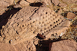
Near camp we still had time to explore an area where our friend Richard Engberts reported some shelters with unspecified engravings. With Uwe we set out to find them, and indeed came up on a shelter with a number of neat rows of engraved cupules on the floor.


We spent a lovely tranquil evening at our campsite, watching the almost full moon rise above the low plateau of Twyfelfontein.


Day 7. - Mikberg area - De Riet
We were up at sunrise and after a quick breakfast we set out towards what Peter Breunig called Rhino Spring (Mikberg Spring in our 2022 trip account), the richest rock art concentration of the Mikberg area.

The largest concentration of engraved panels is just next to the spring, was good to re-visit in the different morning light that brought out many details which we missed the previous year.


There is a further cluster of sites among a huge pile of rocks some distance from the spring which we failed to see last year, including a panel of paintings hidden in a small niche.


Returning to our car we drove north towards the Aba Huab river, where we encountered a large herd of ostrich pecking their way through the riverbed. We continued to the far side of the broad river valley, where along another sandstone outcrop Scherz recorded a shelter with some very interesting paintings, the only rock art site known to him in the area.


Ururu-grotte (Scherz site 38) turned out to be a very small, low & inconspicuous shelter. Unfortunately it is not far from the settlement of De Riet, and is apparently used as a picnic spot, clearly fires have been lighted in the shelter defacing some of the paintings. Sadly only last year the site was further vandalized, tough from some perspective it could be considered a continuation of the rock art tradition, superimposing the earlier creations.


Returning, we encountered the same herd of ostrich, and soon after a small field of baby dunes in the riverbed, detached from a larger trailing dune that formed in the lee of a small hill. The desert instinct taking over, I immediately pulled towards one of the dunes to have a little fun, only realising past the crest of the dune that the top was not flat or domed, but there was a small depression of about two car lengths in the middle. To cut a long story short, it took about three hours to free the car which in a few seconds was resting on its baseplate with all four wheels merrily spinning. Fortunately for Uwe getting stuck in the sand was a novel experience and he took it in good spirits, but Magdi was less amused...


It was almost dark by the time we managed to free the car, and since we were in lion country, camping in the river was not an attractive option. We started out on the track towards De Riet, and immediately encountered a herd of elephants, some of them uncomfortably close to the track. Having already been chased by wild elephants on our first Namibia trip, it was a tense few moments until we were past them and approached the village of De Riet.


At De Riet there is no campground, but the schoolmaster who greeted us was very kind and opened the visitor centre, so we could use the facilities while camping outside.

Day 8. - De Riet - Mikberg area
As usual we were up at sunrise, well before the village started to stir. With the adventure of the previous afternoon our tires were let down flat and needed air, the schoolmaster provided us with a lad to show us the way to the mechanic shop of a nearby lodge where we could get air in the tires for the rocky trails ahead.


It was mid-morning by the time we aired the tires, returned to De Riet and parted again, heading for the eastern side of the Mikberg area, where last year we found some engravings right next to the track, but there were supposedly many more. This year armed with the correct information we knew that we should have climbed to the terrace just above, where there are numerous other panels. Quite unexpectedly here we met another vehicle, an open 4wd tour bus bringing people from the Twyfelfontein Lodge, apparently these sites are now on the tourist trail.


We drove along a series of valleys to the same spot where we camped in June 2022 when we made an unsuccessful attempt to find Richard Engberts' "Yellow Elephant" site. Last year we misinterpreted the description and entered the wrong valley, running out of time. This year with hindsight we had a reasonably good idea where to look. Magdi stayed with the car, while with Uwe we set out along the same trail. It was midday, but the weather was quite cool, a rather pleasant day for such a quest.


This time we made no errors, after a walk of about two hours we reached the small spring which still had some water in it. A number of large boulders filled the valley leading towards the mountain, we did find several panels of engravings here but not the sought after paintings. From our vantage point we could see another cluster of boulders on a terrace above the spring, there too we found numerous engravings.


Climbing to another higher terrace we finally found what we were looking for, a small shelter with a panel of paintings. At first only the giraffe are visible, then slowly one spots the two yellow patches which indeed are a pair of elephants. The shelter with paintings is surrounded by large boulders with several more panels of engravings.


On the way back to the spring we found another small shelter which had some splendid paintings depicting a herd of antelopes.


With two hours left till sunset it was time to return. We walked back the way we came, and reached the campsite just before the sun went down.


It was our first proper moonless night of the trip, the Milky Way, the large Magellan Cloud and shooting stars put up a remarkable show before the glow of the moon over the eastern hills started to dim the spectacle.


Day 9. - Mikberg area
Driving out of the valley we drove to an area towards the north with a very different geology. Instead of sandstone a cap of softer metamorphic rocks cover the older hard schists, and in a bend of a river valley Peter Breunig and team found a very interesting large site (173-A) in a shallow shelter high up above the riverbed. Intriguingly the shelter contains a multitude of both paintings and engravings, it is a very rare occurrence to find both together. The engravings partially efface some of the paintings, clearly they represent a younger layer.


Our next target was back in sandstone country, Breunig's site 19, a major concentration of engravings and paintings on the now familiar setting of large angular sandstone blocks along a terrace bordering a hillside. Alongside the "Yellow elephant" site, this locality contains the finest ensemble of paintings in the Mikberg area.


In the afternoon we made the long walk to the "Amphitheatre" sites at the eastern end of the Mikberg area. With Uwe we already made a visit in 2019, but at the time we only had a generic description of the locality, lacked precise information on the panels. Unsurprisingly we missed some, including the largest single panel, a little removed from the main concentration. Now we could remedy this omission, also giving Magdi the opportunity to see this lovely site. We also had a different light, which brought out some details not seen on the earlier trip.


It was close to sunset by the time we reached the car. As the end of the track was a pretty desolate place, we drove a short distance to find a more suitable camping spot before settling in for the evening.

Day 10. - Mikberg area - Twyfelfontein - Ugab Game Farm & Lodge
This was our last day at the Mikberg, by the evening we were expected at the Ugab Game Lodge. Despite our mishap with the dune, we have pretty much managed to see everything in our plan. There was one cluster of sites left, Breunig's site 1, about an hour's walk from where we camped. We set out at sunrise on the straight forward route, reaching yet another terrace with strewn sandstone blocks. This locality was less rich than the others we saw, there was just one small shelter with paintings, a nice larger panel of engravings plus some scattered single figures.


Returning towards Twyfelfontain we had one longstanding omission. Scherz reported a fine shelter with paintings few kilometres to the west of "Zeremonienplatz" (now the Twyfelfontein Country Lodge), named Adam und Eva on account of a painted couple (site 40). Somehow we never had the time to make a visit, now it was right along our route, and it was definitely worth the stop. While the paintings are faint, they are quite numerous and reasonably well preserved, something not expected at this often visited site.


A few hundred metres away Breunig and team found several panels of engravings, though the ones we saw were not quite as spectacular as some other localities. Possibly we missed some of the panels as we expected more here.


On the far side of the valley from "Adam und Eva" Breunig and team found another small but splendid site with paintings that was unknown to Scherz (Breunig site 197).


Close to the lodge there is another huge boulder where Scherz recorded a panel of paintings (41/M) and some engravings (Twyfelfontein R). It is within walking distance from the lodge, but somehow o prior trips we never took the time to visit. The paintings are faint but nice, the engravings are somewhat less spectacular.


Our time was up at the Mikberg/Twyfelfontein area, we were expected at the Ugab Game Farm & Lodge by the evening. Passing by Khorixas and the Fingerklip we reached the Lodge by late afternoon.


The Ugab Game Farm & Lodge is a brand new property, it only opened last year on the Omburo Ost farm. It is now a private game reserve and a superb upscale lodge, but for us the main attraction was naturally the rock art sites scattered on the vast property. It was already late in the afternoon, so we settled in to watch all the wildlife that came to the watering hole in front of the terrace, including the four rhinos which live in the secure enclosure around the lodge.


Day 11. - Omburo Ost - Aspro - Eremutua
In the morning we were treated with a splendid breakfast and another spectacle around the waterhole, before we set out with the assistant manager to visit the three known sites of the farm. Strangely Scherz was unaware of any sites at Omburo Ost, though he did record one on the neighboring Moselle farm very close to the boundary fence. However Peter Breunig (who edited the third Scherz volume after the death of the author) in his Archäologischer Reiseführer Namibia does mention the place and sites, so they must have been found by the previous farm owners sometime after the mid-nineteen eighties.


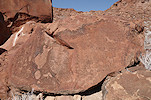
The first site was on an isolated outcrop of dark hard metamorphic rocks, hidden from sight in the low bush until we were practically beside it. The main attraction is a very fine giraffe, but there are numerous smaller figures spread out along the base of the rock.


As we drove towards the main site, we passed a low outcrop some distance from the track. Knowing that the property has not been systematically surveyed for rock art, we gave it a try and right at the first likely spot we found a nice panel of faint but very well executed giraffe.


The main site of Omburo Ost is a more obvious location, a large boulder with a shelter in its side, perched on the top of a low but prominent rocky ridge, with a superb view over the whole surrounding country. There are multiple panels of faint but very impressive paintings in the shelter and further along the sides of the rock.


A quick search of the surrounding rocks yielded another fine giraffe depiction a few dozen metres from the main site.


On the way back to the lodge we passed the last known site, a fine panel of engravings along the side of a detached block along another ridge adjacent to the Ugab riverbed. This too is a site unmentioned by Scherz.


Returning to the lodge we packed and started out immediately, to reach Eremutua by the afternoon. On our way we made a stop at the roadside site we found with Uwe the year before, now firmly identified as Scherz's site 24/A (Aspro farm). This time we also found the panel of engravings at the rear of the rock which we were unaware of the last time we visited.


Much to our luck, the nephew of the farm owner was supervising the charcoal production on the far side of the road. He told us about another site not far from the road, giving us clear directions, so it was not difficult to find the low ridge with a nice panel of paintings along its side, Scherz's site 24/D.


Seeing a prominent rock outcrop a few hundred metres further along the track, and having been given leave to explore we approached the rocks, at the large rock at the northern end we immediately came upon a low shelter with paintings, site 24/C.


The ridge looked very promising, with many shelters and good vertical surfaces for several hundred metres, but a thorough exploration yielded just a single damaged giraffe, nothing else.


With all the stops along the way, it was late afternoon by the time we reached Eremutua to enjoy the wonderful hospitality of Fried, Inken & Jens. There were huge changes, the entire guest building was renovated and enlarged, with three more guest rooms and a new porch added. Two of the rooms were ready, but workers were still completing the other three, to be ready when we were to return with the group in two weeks' time. Just as we settled down for a welcome drink, there was a huge commotion among the workers. Jens disappeared to investigate, and soon returned with a large (already dead) black mamba, the deadliest snake to be found in Namibia.

Day 12. - Kapelle - Eremutua
The main objective of our stay was to continue searching for the remaining sites at Kapelle hill, on communal land adjacent to the border of the neighboring Klein Okombahe farm. Jens made all the prior arrangements, so having been given the keys to the intervening gate, after breakfast at Eremutua we drove to the border fence and continued on foot towards the low outcrop to the south of the main Kapelle hill. Knowing the nasty thorny vegetation to be expected, Jens also equipped us with a fierce looking (but rather blunt) machete, which did turn out to be rather handy at spots. Finding Scherz's site 107/A proved to be easy, it was right at the expected spot at the foot of a large vertical rock face.


Site 107/B was just a couple of hundred metres away along the edge of the rocks, again easy to find at the end of a low and not particularly comfortable shelter.


Site 107/C proved to be much more elusive. It was somewhere hundreds of metres to the north, among the foothills of the main Kapelle hill. Following Scherz's map we fought our way through the sometimes dense bush, collecting plenty of cuts & bruises along the way, but found all likely spots empty. Finally we did come upon a rock face where some paintings were visible, but just a few figures, hardly worth the effort of getting to it (later confirmed to be a new site unrecorded by Scherz).


Magdi decided that she had quite enough of the thorns for the day and returned to the car, while with Uwe we continued to climb the hill, as site 107/D was up there somewhere along the side of a terrace. We found a relatively easy way up on smooth granite without any obstructing vegetation, but as we reached the top all access to suitable-looking spots was blocked, again we had to fight our way through dense thorny bushes. We would never have made it without the machete. Finally after a number of false alarms, we did find the site along the edge of the terrace, at the very last suitable spot.


We took a different way down, and this proved to be fortunate as we had a perfect view over the area we explored where we thought site 107/C to be. Looking back towards the west we saw a very prominent rock face far above where we looked, perfectly matching the description of Scherz. It was becoming too late to go back, but we could easily return the next morning.


On our return we stopped by a couple of large termite mounds in perfect light. One looked exactly like the sorting hat from Harry Potter.


We still had some time remaining till sunset, after returning to Eremutua with Uwe we went out to the adjacent hill to find the two still missing sites of Scherz, sites 106/M and 106/S, both near the north-western summit of the hill. We searched for both already repeatedly, this time climbing right up to the summit Uwe did come upon site S, with a nice rhinoceros on one side of a rock, and a shelter with more paintings on the far side. However after searching the entire north-western hillside, we could still not find M.


Day 13. - Kapelle - Eremutua Nordost - Eremutua
In the morning we returned to Kapelle to check out the rock which we saw from the top of the hill the previous afternoon. Indeed it was the elusive site we were looking for, unfortunately fully exposed to the sun, requiring much shading to photograph all the details. It is by far the largest and most important among the Kapelle sites.


We returned to Eremutua for lunch and a nice siesta before setting out again to visit the Wohngrotte (Scherz site 105) at Eremutua Nordost. We already visited it with Uwe last year, but in the morning, in worst possible light as the shelter faces east. Now we returned mid-afternoon, with most of the shelter already in shade enabling much better photographs, and revealing details which were completely invisible on our last visit.


In the late afternoon Jens took us out on a drive around the southern part of the farm. We did not see any game sparing a very nice spotted eagle-owl (Bubo africanus) and a few kudus which rapidly disappeared from sight, but had a perfect sundowner at a granite ridge overlooking the border fence clearing, with an unobstructed view towards the western hills and the setting sun.


Day 14. - Eremutua - Omandumba
Having found all the sites we set out for at Kapelle, we had a morning left at Eremutua for some exploration. By now the small hill adjacent to the farmhouse was thoroughly searched, and all of Scherz's sites (save for the elusive 106/M) plus a few unrecorded ones were located. However there are a number of smaller granite knolls spread out on the vast property, we set out after breakfast to explore them. We started at two rather prominent hills to the south of the road, which we already passed the evening before, just with the rendezvous with the setting sun we had no time to explore. We spent a good two hours searching all the suitable looking shelters and rock faces, but found nothing, save for a couple of large (60-70cm) lizards basking on the sun, but invariably disappearing into crevasses as we approached. They appeared to be a monitor species, but from the lucky photo of Uwe we could later indentify them as Western Giant Plated Lizards (Matobosaurus maltzahni).


Going back to the northern side of the road we had more luck at a small group of rocks some distance to the East of the main hill. The most likely spot, a good but much overgrown shelter was empty, but at the eastern corner on a vertical rock face we did find some very faint unrecorded paintings.


There is a row of three smaller granite hills north of the main koppie, extending towards the border with the Eremutua Nord-Ost farm. We started at the one closest to the farmhouse, with a large adjacent cattle trough which provided water to a fairly large herd of adolescent bulls, already kept separate from their mothers. It was a strange and not entirely comfortable feeling to approach the koppie while faced with a rather intimidating crowd of cattle heads all turned towards us, clearly hesitating whether to charge or flee... Fortunately they were soon out of sight as we moved behind the rocks, and we were left only in the company of a family of dassies (rock hyrax) as we set out to explore the walls and shelters. Here too at the eastern tip of the knoll we found a large vertical rock with paintings of a giraffe and several other animals, and in the shelter below a strange series of white blobs, which don't make much sense even after the photos are processed with dStretch.


Along the southern side of the knoll we found two further rocks with a few painted figures.


We moved to the next knoll towards the East, where a prominent outlying rock suggested a rock art site from a distance. We were not mistaken, the vertical walls contained a number of faint, barely discernible figures.


Here too we found the principal site of the koppie at the eastern tip, on several vertical rock faces, the largest site found so far. A definite pattern was emerging, for some reason the biggest eastern facing rock was the one with paintings at each of the three visited knolls. Unfortunately here many of the paintings were covered with the excrement of the hyrax which lived on the ledge above.


Not far from here Uwe came upon a delightful little painting of a woman, possibly pregnant, in the company of a rather effaced zebra at the corner of a large rock.


The third knoll was a little more distant, not far from the eastern border fence. With the previous experience we went straight for the prominent rock at the eastern corner, and were not at all surprised to find some fine paintings on both sides of the rock.


It was early afternoon by the time we finished with all the koppies, we returned to the farmhouse for a quick lunch then packed and departed for Omandumba, our next and last destination.
Day 15. - Omandumba - Ukurenz - Kamelnek
We used the Bush Camp at Omandumba as our base, but our principal target was the region of low granite ridges between the village of Ukurenz and the D2315 road leading to Omandumba. Scherz called this area Okombahe, Ukurenz (95). Some of the sites were already known in the nineteen thirties, and were visited by Breuil in 1948 and 1950, though no copies were ever published. Scherz recorded a total of 25 sites here, but to complicate matters only 11 were marked on his sketch map, which I was unable to match with any confidence to the actual terrain. The site descriptions were equally vague, there was only one, the 95/A "Schlangenblock" (snake rock), described to be a large free standing boulder, which could tentatively be identified as a large rock visible on Google Earth. While it was well past some other nearer sites, we decided to start at this known boulder, as if our hunch was proven correct the map would help in finding the other nearby sites.
Arriving at the boulder we immediately found a large panel of paintings on the southern side of the boulder, and consulting the Scherz volume they did appear to match the description of the paintings. However the snake after which the site was named was nowhere to be found. Finally after much searching we did find the now very faint figure behind a shrub that overgrew the site, on the side fully exposed to the sun. Fortunately we had the option to return the next day for some gardening and better light.


According to Scherz site 95/B was somewhere 300m to the east of the "Schlangenblock" on another boulder. It was a good illustration of what to expect from the Scherz map that we found it (though quite straight-forwardly) at a distance of 800 metres.


Site 95/C was supposed to be another 100 metres eastwards, on a small boulder on the ridge. We could not continue with the car so set out on foot with much misgivings, and were very surprised to find the site without any real searching a mere 10 metres from the described spot.


Site 95/D was supposedly 150 metres to the south of 95/A (snake rock), from satellite imagery it appeared better to drive around the ridge and try to approach from the south. In the end after quite a bit of searching we did find the prominent split boulder at a good double of the given distance. This one turned out to be a quite impressive site, with several panels of fine paintings around the rock.


It was past midday and it was starting to become rather hot, we returned to Omandumba for lunch and a little siesta before continuing our exploration mid-afternoon. Scherz recorded a number of sites to the north and south of the track leading to Omandumba, Daunabis-grotte (94) and Kamelnek (97), the exact position of which were unclear. We did find a number of sites on both sides of the D2315, but none of them could be matched up with any of the reported sites. We started out at a couple of granite outcrops north of the road which looked promising, and immediately found a large rock with some remnants of paintings on the south side, but again not matching anything published.


A short distance away, right next to the road we found another site at a likely spot, again with some very effaced paintings that could not be matched with anything known.


In 2019 we spent quite some time looking for the Kamelnek (97) sites south of the D2315 along the foot of the Erongo. We did find a few sites, but on close scrutiny these turned out to be the Naueb (96) sites. In the mean time I learned that "Kamelnek" was not referring to the shape of the mountain, but it was the name of a small village of a few houses to the north of Tubusis. This made it likely that the track marked on Scherz's map as leading towards Omandumba was not the current D2315, but the direct by-pass from Tubisis, and the sites should be searched for to the East of this track. The hunch turned correct, as when we drove to the edge of the mountain at the western edge of the embayment paralleing the track, we immediately found a rock with paintings, even though these did not match any of the sites described by Scherz either.


Continuing eastwards we soon came upon another site, the three giraffe depictions finally matched Scherz's site 97/B


Nearby Uwe found another small site with a solitary Oryx and some unidentifiable animals. While according to the map this site should have been further west (where we did find the first site), the description did match some of the depictions at Scherz 97/A.


If our identifications were correct, site 97/C should have been somewhere 200m to the East on a boulder at the foot of the Erongo. It was a little further, but well within the usual distance errors of Scherz, a huge boulder with numerous paintings which finally matched fully the descriptions.


By the time we finished taking the photos the sun was rather low, we made our retreat to the Bush Camp for a sundowner and dinner, to continue the next morning.
Day 16. - Omandumba - Ukurenz


Site 95/E was somewhere at the eastern end of the same ridge. It was another lengthy search until we found the site on a north facing rock overlooking the valley.


Site 95/K was marked to be on the ridge immediately to the north of the valley with 95/A. We parked the car at the foot of the ridge and ascended to the likely spot, immediately finding a large shelter with numerous paintings. We were convinced to have found site K, but later we realised that in fact we have unexpectedly stumbled upon site L, the "cave of the black elephants" which was not marked on the map.


As at this point we still thought we already found site K, we continued the low ridge to the north-east where we expected to find sites F-I. Of course we found nothing, but some distance to the west there was a large prominent boulder that looked promising, and indeed we found numerous panels on both sites of the rock, as well as at the adjacent one. With the Scherz book in the car it was not clear what we found, again it was only later that we realised that this in fact was the true site K.


Not quite sure what we found, we continued westwards along the edge of the ridges, turning south before returning towards the car. At the western tip of the first ridge we found a large overhanging rock with a single recognisable giraffe and some effaced paintings, later identified to be Scherz's site 95/Z.


We still thought that site L was in fact site K, so we set out to look for L at the end of the ridge of site A. There were many boulders with suitable rock faces, on one of them Uwe spotted some paintings, which however looked nothing like the dark elephants we were looking for. We returned to the car to match our photos with the sites, and slowly the realisation sank in that we in fact did find both L and K (and Z). This last site was apparently not recorded by Scherz, as he did not assign J for some reason (consistently at all other localities too), we designated this new site 95/J.


Having re-gained our bearings, it became clear that we should be looking for sites F-I on the far side of the ridge facing site B, a good kilometre to the east. Driving past B we left the car at the foot of the ridge and crossed over some granite plates, finding a deep descent of the far side, with a depression in the rock still holding water, a rather unexpected find.


Now Scherz's map started to make sense, we found site 95/F right where it was expected, and 95/G a few dozen metres from it.


Site 95/H was another hundred metres further east on a cluster of boulders at a very obvious and prominent location, with several panels of paintings scattered about the rocks.


The last of this cluster of sites was 95/I, the "Eland shelter". Scherz's description was rather vague, but this time we had no difficulty, we readily found the small low shelter a few dozen metres beyond site H.


By this time it was mid afternoon. We returned to the car and drove back to site A, where the side with the supposed snake was now in good shade. After some gardening we could clear the panel and take decent photos of the very faint scene, which does not appear to be a snake at all.


Now that we realised which sites we found, we could see that site M with a panel of ostriches was described to be to the west of L along the edge of the same ridge. We returned to site L, and continued along the edge of the rocks, and at a large boulder we did find the site, as usual at more than twice the distance than where Scherz described it to be.


By the time we got back to the car it was rather late in the afternoon, and we found most of the sites with a reasonably clear description. There was only one left where the location was rather obvious, site 95/W at the northern edge of the village cemetery located at the southern edge of the cluster of granite ridges. The site is in fact incorporated into the graveyard, a rather unique example of present-day inhabitants forming a direct link with their ancestors. It was good to see that the site was respected and protected, there were no signs of any recent damage.


Day 17. - Omandumba - Windhoek
Our time was up, we were to depart on our Namibian Rock Art tour the following morning. Uwe decided to stay in Omandumba for a few more days with a friend, while with Magdi we packed up for the drive back to Windhoek, where I was to deliver a talk on Saharan rock art at the Namibia Scientific Society that evening, before starting out on the second part of our trip the following day.

For June 2024 we are planning a 16 day circuit to see a wide selection of the Rock Art sites of Namibia plus some of the natural wonders of the country, staying at lodges and guest farms along the way. Please visit the News page for any updates (or "follow" the FJ Expeditions FaceBook page).