
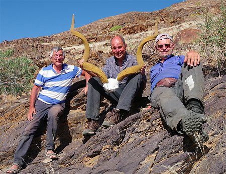
 Click on image for list of participants |
Upper Brandberg and Mikberg 10th - 22ndJune, 2025 Site references based on numbering system of Harald Pager (Upper Brandberg) and Ernst-Rudolf Scherz False colour images processed with dStretch, a freely available software developed by Jon Harman |
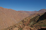
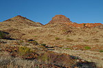
Day 1. - Windhoek - Uis - Sonuseb Gorge
Having been informed of the good rains in advance by Otja (with whom we were up in the Tsisab last year), we planned to spend four days on the Brandberg, ascending the Sonuseb Gorge to the Nuwuarib, then making our return via the Tsisab. With flowing water in the Tsisab, we could expect to find water on the mountain, avoiding the need to carry a heavy load of water like on previous trips, which severely limits one's range and endurance.
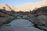
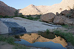
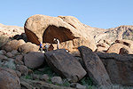
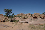
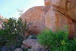
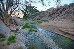
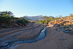
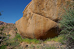
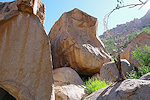
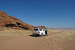
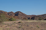
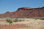
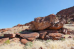
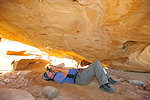
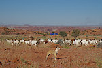
I arrived the previous afternoon via Jo'burg, Bruno and Uwe took the direct Discover flight from Frankfurt arriving in the morning. After a quick shopping at the Maerua Superspar we departed for Uis. We reached the Brandberg Rest Camp for a late lunch, then departed to the Tsisab office, followed by Basil who was to take us to our drop-off point at the start of the Sonuseb trail. Otja was awaiting us at the agreed time, and leaving our car at the Tsisab parking lot, we continued with Basil to the trailhead some distance to the west of the White Lady Lodge. The start of the Sunuseb trail is not in the gorge itself (which discharges into the Ugab river to the north of the mountain), but at the eastern foot of the mountain, where a low ridge separates the plains to the east from the Sonuseb, allowing a faster route into the gorge. We had enough time to scale the ridge, descend into the gorge, and make it a few hundred metres upstream to camp beside a series of pools, to the sound of trickling water.
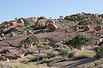
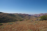
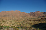
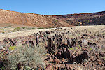
Day 2. - Sonuseb Gorge
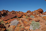
Sonuseb is the only gorge of the Brandberg which I have not visited before. From Harald Pager's diary it is clear that it was used as an easy access route up to the Nuwuarib, with porters making the trip from Nuwuarib down to the car and back in a single day. Our aims were somewhat less ambitious, we hoped to make it to the top by the evening, something that apeared entirely feasible. Viereck found a reliable water hole some way up the valley with some nearby rock art sites, we also hoped to find these along the way.
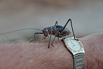
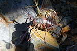
We were up at dawn, and ready to leave by sunrise. Just like in previous years with good rain, the fearsome looking (but completely harmless) big spiny crickets (Acanthoplus longipes) were everywhere, but they did not bother us at all during the night, they too started to stir only as we got out of the sleeping bags.

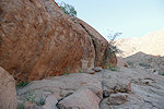
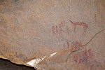
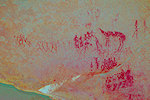
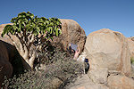
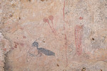
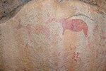
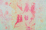
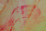
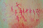
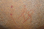
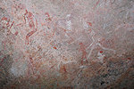
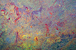
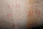
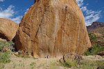
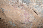
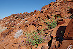
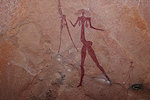
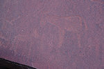
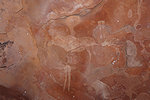
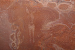
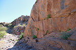
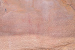
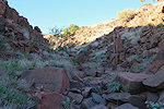
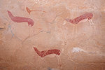
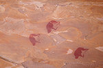
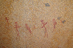
From our campsite we started out on a gentle gradient, and in 20 minutes we found the first rock art site on a rock wall bordering the watercourse to the east. Viereck mentioned these sites in a letter to Pager, but without any details, and Pager himself did not do any documentation here, so I just assigned numbers to these sites in the order we found them. As Pager assigned "B" to the Sesaub sites, it is very clear that he intended to use the S prefix for the Sonuseb sites.
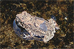
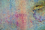
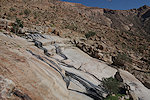
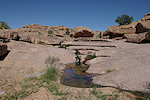
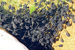
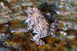
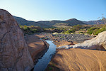
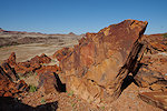
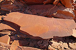
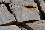
A short distance further upstream we came upon a series of pools with water flowing over the smooth sloping granite in places. The wet patches were overgrown with algae and were extremely slippery, in places we needed to search for quite some time before finding a safe place to cross. There were tiny toads (Hoesch's Pygmy Toad, Poyntonophrynus hoeschi) living on these slippery algae patches, one of which bordered a big rock with some faint figures on it, it was impossible to approach for better photos.
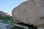
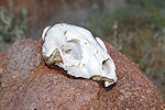
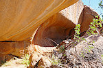
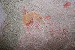
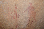
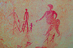
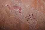
A little further we found the large patch of reeds mentioned by Viereck as marking the reliable water source, and on the opposite side of the river along the side of a shallow shelter we came upon a fine large panel of paintings, undoubtedly the ones mentioned by Pager in his diary as next to Viereck's spring. We did a search of the rocks on the far side of the watercourse, but only found the skull of a juvenile Leopard, the closest I ever came to seeing one on the Brandberg.
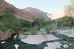
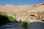
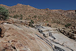
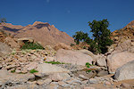
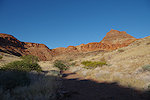
From the reed patch the valley continued for another kilometre with a relatvely gentle rise, until we reached a steep smooth granite slope from where it started to rise rapidly. We found a small waterhole with good water (and plenty of tadpoles (of Marbled rubber frog, Phrynomantis annectens), a sure sign that the water is good to drink) near a rock that offered some shade, our last stop before starting the ascent in earnest.
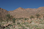
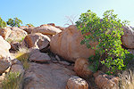
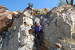
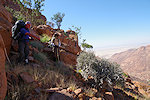
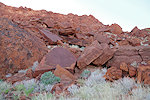
From hereon it was just the long grind up the steep slope among the granite boulders, aiming for a break in the vertical cliffs bordering the valley. It took us all afternoon (with a good hour of backtracking, as our initial route ended at an unscaleable rock ledge), we reached the top of the cliffs at dusk a good hour after sunset, immediately preparing a bivouac at the first suitable flat spot.
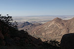
Day 3. - Nuwuarib Gorge
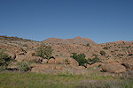
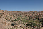
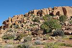
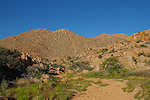
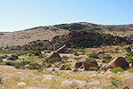
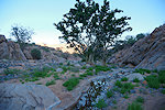
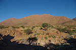
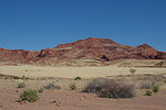
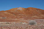
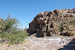
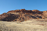
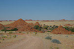
The top of the Sonuseb is capped by a remaining uneroded patch of Karoo basalts, which millions of years ago covered the entire batholyth of the Brandberg. It appeared to be a deceptively easy terrain after the steep climb on the granite slopes, but underneath the high grass the ground is covered with football-sized boulders, making traverse very unpleasant but unavoidable, as we needed to move towards the est to cross the watershed into the Nuwuarib Gorge.
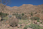
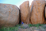
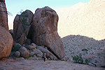
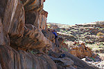
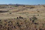
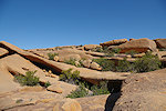
Fortunately after reaching the rise along the watershed we soon reached granite terrain, and the going became much easier. There are a couple of flat plains along the edge of the drop into the Sonuseb (already draining into the Nuwuarib), they looked like good living sites, but despite finding several likely-looking boulders we found no paintings until reaching W26, a site we already saw in 2013 when exploring the eastern parts of the Nuwuarib with Uwe and Jon.
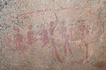
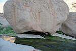
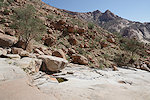
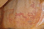
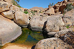
We continued descending into the main Nuwuarib valley, and followed the watercourse downstream beyond the last point visited on previous trips. Mason reported two sites here, Jipsen a third, none of which were marked on Pager's aerial map, and I only became aware of the Jipsen report following that trip. This time we could go straight to the right locations, as Jipsen described the larger of the three sites (Mason VII, Jipsen 23) under a flat rock next to a dry waterfall before the valley starts the steep descent, following the main watercourse we reached it a mere 10 minutes after the last known point. Here too we found a big pool that was full of tadpoles.
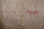
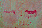
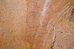
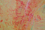
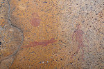
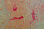
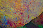
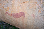
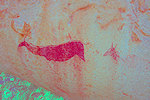
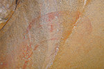
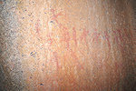
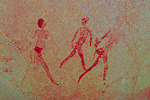
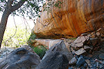
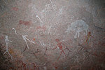
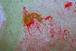
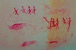
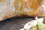
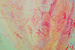
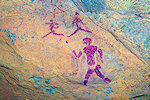
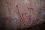
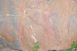
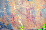
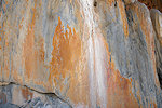
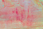
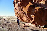
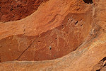
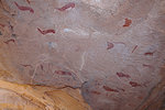
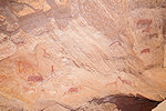
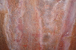
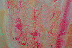
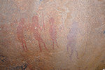
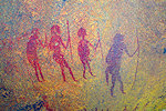
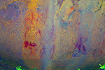
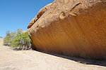
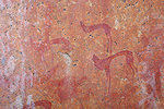
The site itself (W30) is in the shelter under the rock, with many figures, but mostly faint requiring dStretch to fully appreciate.
Another site (Mason VIII, Jipsen 24) was supposedly somewhere a short distance downstream along the eastern side, we checked all likely spots for the nice rhinoceros hunt scene but were unable to locate it. We had more luck on the return with Jipsen's site 22 (W29), it was right there along a granite ridge where I expected it to be based on the description.
We returned to the lower cluster of sites, the huge "Bildergalerie" (W16) and Jipsen's site 20 (W14), mostly for the benefit of Bruno for whom this was the first visit, but with Uwe we also enjoyed being able to see them once again after a gap of twelve years.
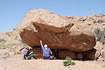
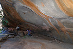
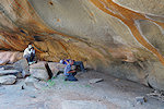
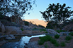
By midday we reached the Mason Shelter (W1) where we intended to camp. The pool next to it was full, so we had no shortage of water, a rare luxury on the Brandberg. Not having to carry more than a bottle of water made this climb and trek so much easier than our climb a year earlier. The midday break was mostly spent in the Mason shelter, where with my new 16mm lens I could finally capture the scene on the ceiling in its entirety.

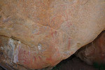
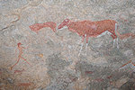
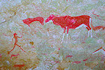
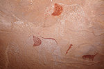
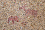
In 2013 lacking the Jipsen report, we could only look for the sites marked n Pager's aerial photo, which was bu no means complete. Following that trip I found the Jipsen report in the library of the Namibian Scientific Associattion, and it became clear that there are a number of sites upstream of the Mason shelter. By sheer luck in 2013 I did find the "Elephant shelter" (W21, Jipsen 6), but there were two more sites nearby. In the afternoon started at the more distant one, (W34, Jipsen 5) which was right at the expected location, two fine elands of which one is almost completely obliterated save for the head.
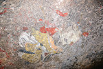
Walking back towards the "Elephant shelter" Bruno checked a few rocks, and on the side of one of them found a splendid little scene within shouting distance of the other sites which has apparently missed buy both Mason, Jipsen and Pager. The paintings are faint but readily visible, and it appears to have a scene depicting hairdressing, something relatively common in the Sahara but I'm not aware of any parallels at the Brandberg or elsewhere in Namibia.

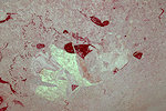
At the "Elephant shelter" (W21) I took some better resolution photos than last time of the large indistinct shapes, but they still don't make much sense, the only thing I'm quite certain about is that they are not elephants. Jipsen also marked one nearby site (7) on his map towards the north west along the edge of a small plain, but despite a thorough search we could not find it. For the rest of the afternoon we continued along the remaining known sites in the area until sunset forced us to retreat to our bivouac next to the Mason shelter.
Day 4. - Nuwuarib Gorge - Scherz Basin (Tsisab Gorge)
Jipsen reported a cluster of four sites about a kilometre and half upstream of the Mason shelter, on the largish "Half Moon Plain". The tough location was evident on Google Earth, in the morning we set out with our packs to visit these sites before making the descent into the Tsisab. It was an easy short walk to the plain, and at the near edge we immediately came upon the big boulder shaped like a half-moon giving the name to the plain (W35, Jipsen 4). We found the paintings on the southern side, all very faint and damaged.
The other three sites were not so evident, we found W37 (Jipsen 2) nearby, but the other two we had to search for as the rocks were not perticularly obvious. All the found scenes were rather faint and unspectacular, the visit to these sites was more for completeness than anything else. W38 (Jipsen 1) had a few nice human figures, but W36 (Jipsen 3) was just a few smudges on a low rock.
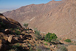
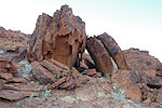
Leaving "Half Moon Plain" we ascended a low rise to the watershed with the Tsisab Gorge, and for a short while we again crossed the eroded basalt cap until reaching the edge of a steep drop into the Tsisab towards the Scherz Basin. The descent was unpleasant but doable, with much loose scree on the slope interrpted just for fun by several metre high phonolite cliffs where we had to scramble down. It was nearly two hours to make it down to the riverbed below, a good 250 metres lower than our starting altitude.
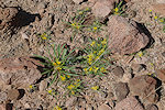
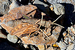
It was midday by the time we reached the riverbed, it was time for some lunch and a good rest before continuing. It was also a good opportunity to spot a couple of interesting plants and visitors, including a nice big spiny cricket and a pair of mating shieldback locusts.
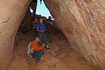
From our rest-stop it was a good further hour to reach the Lange Grotte (T200), one of the largest sites on the entire Brandberg, and certainly the principal site of the Scherz Basin and the upper Tsisab. This time we did not find any water near the entrance of the shelter, which was a bit disconcerting as we expected water in the Tsisab and our bottles were nearing empty. However we left these worries to later, and prceeded to the shelter for a long photo session.
Once finished we made the difficult scramble down to the level below the shelter, and we did find some seeping water inhabited by a few pogmy toads, but it did not look very attractive. Fortunately we soon heard the yell of Otja who went ahead, he found a pool with good water so our problem was solved for the time being.
We still had plenty of daylight left, so we followed the dry riverbed downstream, till we reached the confluence of the Kohlrabi valley that leads up towards th Königstein peak. The Kohlrabi was still in full flow, and on a nearby sandbar we found a perfect bivouac spot so we could start out with full bottles the following morning.
Day 5. - Tsisab Gorge
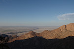
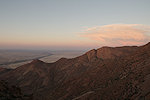
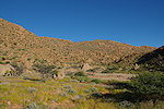
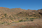
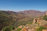
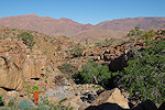
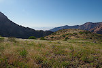
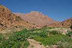
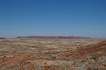
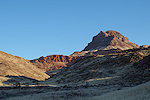
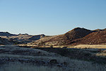
In the morning we followed the watercourse along the Scherz Basin for some time, then turned east, following the contour to the extent possible to make it towards Bertha valley and the sites recorded by Jipsen on the northern slopes of the Tsisab below Bushmanfels. Last year we alreasy attempted to reach these sites from the Upper Tsisab, but the lack of water and the long detour made us to abandon this plan. Now the sites were within easy reach, after a by Brandberg tandards very easy one hour trek we were on a col with a superb view over the Scherz Basin and Königstein on the western horizon.
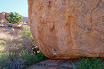
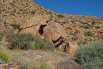
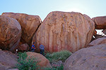
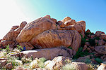
The progress along the contour then the descent into Bertha valley took another hour, by mid-morning we were approaching the big conspicuous boulder (site T208) with "Big Bertha" on the side accompanied by numerous other figures.
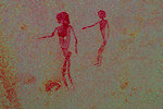
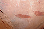
On the slope to the east of the watercourse traversing the valley there was another site, Jipsen's "legless shelter" on account of a row of figures which appeared to lack legs. This site proved stubbornly difficult to find, we seached all the likely boulders until finding the panel at the last and least likely cluster of rocks. dStretch shows that the "legless" figures are very much normal, just the legs ar indeed very faint and indiscernible.
At this point the only thing left was to make it down to the bottom of the Tsisab, where we planned to spend another night near the Altan Eck waterhole before heading down to the car at the parking lot at Tsisab entrance. From 2013 I remembered that the way down to the Tsisab bottom was very steep and difficult, after a midday rest we started our way down. It was clear that the watercourse descending from the Bertha valley was impassable, we selected the boulder-strewn slope to the east to at least save on distance. At first the going was reasonably good, but near the bottom we reached granite plates with several dead-ends, it took a considerable back-tracking upslope again till we could find a suitable way down, in the end it was close to sunset by the time we reached the riverbed.
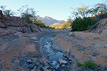
At the bottom we had a nasty surprise. We fully expected the Tsisab to be in flow, as there was flowing water in the Scherz Basin, and Otja said that the river was still flowing at the White Lady. However the section we reached was completely dry, and the big water hole where we had our midday break a year earlier was also empty & dry. Otja and Uwe went a little further in the rapidly setting darkness to find water, but came back empty handed. We held council, in the end we decided that we had just enough water left to make it through the night, and in the cool of the morning we can make it down to the Tsisab Island where we will be able to find water again.
Day 6. - Tsisab Gorge - Uis
In the morning we started at first light to cover the few remaining kilometres till the Tsisab Island. Reaching the end of island, again we found al the waterholes dry. As we have all visited the majority of the Tsisab Island sites before, we just made some brief stops to photograph missed details, then continued to the eastern end of the island, where after descent we indeed found flowing water in the river. The water must flow underground for a considerable time before it emerges just below the island, which probably explens the concentration of sites there, and the scarcity of others further upstream along the valley.
By late morning we reached the car, and after saying good bye to Otja and all the other guides at the Tsisab office, we drove into Uis for a nice lazy afternoon by the pool at the Brandberg Rest Camp.
Day 7. - Uis - Messum Crater - Cape Cross - West Brandberg
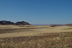
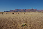
The only time we visited the Messum Crater was in 2005, on our very first visit, somehow there was never any opportunity to go back. This was recified this time, both Uwe and Bruno were keen to see an area they have not been to before, so in the morning we set out of Uis after topping up our fuel and supplies at the Brandberg Supermarket. The Messum Crater is not really a crater in the proper sense, it is te eroded remnants of a very ancient volcano that was active at the time when the Atlantic rift opened and Gondwana split into Africa and South America. In the centre there are several granite hills, the remnants of the solidified magma chamber after the volcano became extinct, with erosion remving several kilometres of overlying rock. There is a single rock art site there in a low shelter, the first ever site I have seen in Namibia. It was nice to have the opporunity to re-visit, and of course see many details which I have missed on that first encounter (the site was recorded by Scherz as Fundstele 86).

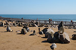
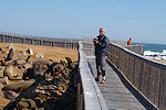
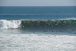
While at the Messum, we though we might as well visit the Cape Cross seal colony, which is just a few dozen kilometres further, and again I have not been there since 2005. We found the place much improved in the elapsed 20 years, now there is an elevated walkway that enables visitors to walk right over the centre of the colony without disturbing the animals who appear to be completely accustomed to visitors. The walkway enables closer view of the ocean too, with the throng of seals fishing in the waves.
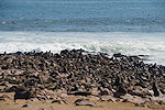
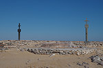
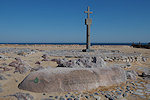
The Cape itself derives the name from the stone cross the Portugese have erected here in 1486 to commemorate their first landing on the South West African coast. The original cross is long gone, but both the German and the South African administrators felt compelled to commemorate the event on significant anniversaries by erecting replicas. The seals, who have been here for thousands of years, don't seem to care much...
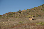
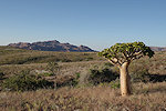
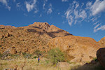
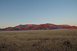
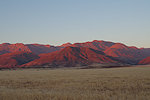
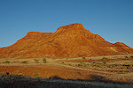
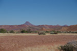
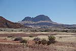
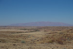
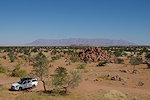
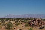
In the afternoon we retarced our route across the Messum Crater, spending the night off the West Brandberg road in full view of the mountain at sunset when it becomes true to its name.
Day 8. - Mikberg area
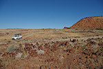
Our target for the next 3 days was to visit a number of sites recorded by Peter Breunig and companions in the Mikberg area, plus one of Scherz's sites which we did not yet visit. As it was the first visit to Bruno, we also wanted to take in some already visited highlights. We took the usual route from the south, passing the West Brandberg mine and crossing the Ugab river before heading north.
First we visited a series of known sites in the southern parts of the Mikberg, hen we continued along the transverse west-east trail to the sandstone hill known as the "Molar", the slopes of which are littered with panels of engravings. With Uwe we have already found some of them in 2022 and 2023, but subsequently with more information from Peter Breunig I realised that there is much more that we missed, including a shelter with paintings. This time, armed with correct positions, we could find all the sites, the panel of paintings turned out to be a really nice one.
By the time we finished, it was late in the afternoon, we drove in to the adjacent Ballon Valley (no idea where it got it's name from, perhaps from some balloon shaped engravings at the cluster near the end) and chose a suitable sandy patch in the main watercourse to spend the night.
Day 9. - Mikberg area
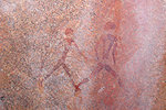
Our bivouac was positioned to provide the closest access to a cluster of sites along the southern side of the "Molar". We set off at sunrise to make the 1.5 kilometre trek to the rock filled terrace (Breunig sites 101-104), passing by a lesser engraving (Breunig 64) in the canyon that is the true entrance of he Ballon Valley. These engravings were not as spectacular as the ones on the northern side, but we were there in the morning shadow, perhaps a visit in the afternoon is more rewarding. There is also a shelter formed by a split sandstone slab with some white paintings inside, including a lovely gazelle depicted from the rear (like those in the Lufthöhle on the Brandberg)
We continued along the track past the "Molar" towards Doros crater and the south-eastern corner of the Twyfelfontein sandstone plateau, to see the sites reported by Breunig and Scherz in the area. We drove alons some spectacular landscapes, until the point where both Doros crater (seen as a rise on the horizon, we did not enter) and the Brandberg came into view.
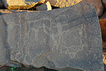
Our targets were two clusters of sites, Breunig 114 & 115 at the very south-eastern tip of the sedimentary sequence overlying the ancient folded metamorphc rocks of the Ugab belt. The sites are all located along the walls of a gorge cutting through the ridges of folded rock, a short walk away from the nearest track. The fist cluster (114) was on both sides of a ridge of very hard metamorphic rock that formed a barrier in the riverbed (with a now dry waterhole at its base), with some faint paintings and engravings at numerous vertical surfaces, none of them exceptional.

The second group (115) was two sites of paintings a coupe of hundred metres downstream, we expected some shelters but the very faint and damaged paintings were on vertical surfaces, now much defaced by dassie excrement, in retrospect not quite worth the effort needed to get there.

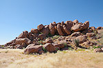
Returning to our car we backtracked a bit to reach the trail circling the Twyfelfontein plateau, and on reaching the first sandstone outcrop we reached the cluster of sites Scherz recorded as "Süderecke" (Breunig 143). The panels of engravings are on boulders at the foot of the talus slope, a very typical location. There are a number of unique spiral and oval motifs not found elsewhere alongside the more common animal depictions, and there is also a small shelter with a few very weathere painted figures.


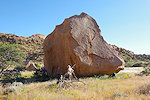
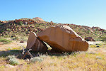
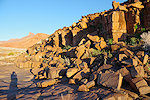
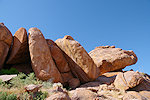
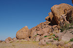
Continuing north towards Twyfelfontein along the edge of the plateau we encountered a field of geologic oddities, rounded uprght stones which at first appeared to be erected by humans, but on close look it became clear that they were eroded natural basalt columns.
We continued past Twyfelfontein towards our campsite in the valley leading to the access trail towards the "Amphitheatre". On the way we stopped briefly at the "Adam und Eva" site of Scherz, which now in the late afternoon was almost completely out on the sun, bad for the paintings but very good for the lightly engraved panel of zebras which now was perfectly visible.
Day 10. - Twyfelfontein west
Scherz reported a shelter with paintings to the east of the "Amphitheatre" a large almost circular basin with some splendid engravings (originally located by Joe Walter) about 10 kilometres to the west of the main sites of Twyfelfontein. This "Elefantenplatte" (Scherz fundstelle 39, Breunig site 3) is a little out of the way if one is going to the "Amphitheatre", and the description of Scherz did not sound exciting enough to warrant a lengthy detour. Now with enough time on our hands we decided to start there, then continue to the "Amphitheatre" to see the engravings. The ascent was via a fairly easy series of steps along a riverbed to the grassy terrace flanking the high-rising sandstone outcrops.
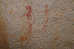
We found the site in a small shelter under a large boulder, the paintings turned out to be far more impressive than expected. Aside the splendid elephants there was a very fine panel of assorted antilopes and gazelle, all in an excellent state of preservation, making this site one of the nicest panels in the area.

Near the "Elefantenplatte" we found a curious upright slab, there were no markings on it, but certainly someone put it there sometime with a purpose. There were also a number of other rocks, but apparently all void of rock art.
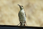
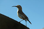
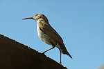
Bruno & Uwe continued to the Amphitheatre, while I decided to return to the car. Since the start of the trip on and off I has some pain in the right knee, while it did not prevent me from climbing the Brandberg by this point it was persistent enough that I decided scrambling on the rocks in the Amphitheatre is probably not something I want to do. While I waited for the others in the car catching up on some work (there was mobile signal, thus internet) I was entertained by a female Dusky Sunbird (Cinnyris fuscus) that continued to come back, sitting on the car mirror or on the edge of the window. Normally they never stay still long enough to photograph, but this one repeatedly posed for over a minute.
By the time the others returned from the Amphitheatre it was almost sunset, we drove back to the same bivouac spot beside some trees and a nice sandy patch in the riverbed not far from the trailhead.
Day 11. - Twyfelfontein west - Sorris Sorris - Uis
In the morning after packing up we headed up the eastern slope bordering the valley to see the splendid Breunig 19 cluster with some excellent engravings and paintings. With Uwe we have already seen it in 2023, but being so close it would have been a shame to allow Bruno to miss them.
In his Archäologische reiseführer Namibia Peter Breunig mentioned a small hill with paintings in the vicinity of Sorris-Sorris, a small town to the east of the Brandberg (the principal settlement of the area before the tin mine opened and Uis was developed in the nineteen fifties. The location was just off a secondary road leading to the town then continuing to Uis, we decided to take this shortcut to see the site and also explore this route. There actually was a sign indicating the rock art site bu the road, with a small parking area at the foot of the hill. There was an obvious shelter in the side of the hill, where we immediately found some paintings, though not the panels illustrated by Breunig.
True to his habit, Bruno started looking around, and soon he found a second panel among the rocks, then another, then another... In the end going around the dumb-bell shaped double hill we located a total of nine separate panels, some with nice scenes. Bizarrely none of them match the two photos attributed to the site by Breunig.
It was mid-afternoon by the time we finished photographing the sites, we continued past Sorris-Sorris and the picturesque granite hills, crossed the Ugab river (there is no bridge on this road so only passable in dry season, and even then sometimes only with 4WD in the deep sand) and continued to the Brandberg Rest Camp for the night.
Day 12. - Uis - Ameib - Windhoek
During the trip we managed to communikate with Sigrid at Ameib, and we could arrange a visit to the magnificent Jatow Grotte on our way back to Windhoek.
We reached Windhoek in the afternoon, Uwe continued for some more days in Namibia while with Bruno we departed the next morning to continue exploring rock art in Zimbabwe.
For June 2026 we are planning a 12 day circuit to see a wide selection of the Rock Art sites of Namibia on a more modest budget, staying at campsites and guest farms along the way. Immediately after this trip in early July 2026 we plan to make another trip to the equally splendid Rock Art sites of Zimbabwe. Please visit the News page for any updates (or "follow" the FJ Expeditions FaceBook page).